Geologists and geotechs capture the data. Engineers and miners need it for decisions. Everything in between is where projects lose time, context, and confidence.

Site mapped. Conditions assessed. Data captured by your field team across multiple active projects.


Notebooks. Spreadsheets. Verbal summaries. Data loses structure, context, and urgency.

Planners and engineers work from incomplete information. Decisions that should take hours take days.


Geologists spend hours chasing survey coordinates just to place scans in space. While survey catches up, geological and geotechnical data sit in limbo, and so do the decisions that depend on them.
Most platforms force mines into fixed naming conventions and static forms. When the structure doesn't match the workflow, the logic behind headings, rounds, and observations gets lost.
What begins as direct observation at the face ends up as a simplified 2D interpretation, digitized, scaled, and repositioned in 3D. With every handoff, geological context drops away.

Capture 3D scans with Lithos to map orebody extents and structures in minutes. Classify each round before the next blast and sync to Strata for a shared 3D geological record.

Standardize underground geological data capture. Map and characterize features in 3D, compare conditions with the Ground Control Plan, and justify support decisions while keeping documentation in one web platform.

Enter design reviews and production meetings with confidence. Strata presents annotated 3D models that align geology and geotechnical teams on stability and extraction sequencing.
Fewer delays between capture and action.
Stronger decisions around ground support, geology, and design.
Reviews start with shared context, not a scramble for data.
Workflow Analysis
PDF DELIVERED


"We used to spend the first twenty minutes of every RES meeting just finding the data. Now it'sthere before we walk in. The conversation starts at the decision, not the search."

"We used to spend the first twenty minutes of every RES meeting just finding the data. Now it'sthere before we walk in. The conversation starts at the decision, not the search."
"We used to spend the first twenty minutes of every RES meeting just finding the data. Now it'sthere before we walk in. The conversation starts at the decision, not the search."
"We used to spend the first twenty minutes of every RES meeting just finding the data. Now it'sthere before we walk in. The conversation starts at the decision, not the search."
"It's the easiest way to collect data underground and the easiest way to get it into a database and interpret it later. That's what's needed in this industry."
“This is going to help out younger staff who haven’t done a lot of mapping before. They need guidance, but it’s hard for me to do remotely without seeing it. This platform helps a lot.”
"We’re able to identify potential hazards and make data-driven decisions that improve safety and efficiency on site.”
"There is absolutely subjectivity to any mapping, and so to have some sort of concrete documentation that people can look at side-by-side and make a final determination of ground conditions is exactly what we need."


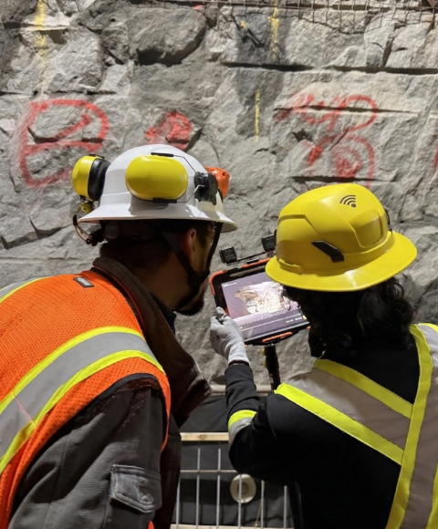
Captures geological and geotechnical data on iPad, or imports scans from your existing hardware.Underground, offline, at the face.
Data captured in Lithos flows directly into Strata Grounded platform, where teams can reviewconditions, generate reports, and align on decisions.

See how GroundedAI connects underground observations to daily mining decisions.

© 2026 GroundedAI. All rights reserved.
Vancouver, BC · EN