

Your team inspects the tunnel every day. Your engineers need that data for support decisions, baseline reviews, and reporting. The current workflow was not built for the pace of production.

Tunnel scanned. Features mapped. Geological and geotechnical conditions documented for the next push.


Sketches photographed. Notes transcribed. Data re-entered into spreadsheets hours or days later, if it gets there at all.

Engineers and managers work from yesterday's data on today's conditions. Owners ask for records that take days to compile.


Tunnel construction moves fast. When tunnel mapping can't keep up with advance rate, the geological record falls behind, and so do the decisions that depend on it.
When ground conditions don’t match the baseline, the documentation trail matters as much as the engineering response. Assembling that record after the fact is expensive and unreliable.
Owner's engineers and commercial teams need structured data, not a narrative reassembled from field notes months after excavation.

Standardize geotechnical data capture underground. Consistent inputs feed directly into support class decisions, design validation, and construction records.

Document divergence from baseline conditions in real-time underground, with structured data. Build the record as it happens, not weeks later in the office.

Capture discontinuities, joint orientations, and structural geology underground. Maintain a continuous geological record tied to chainage and advance.
Geological records that keep pace with daily advances.
Differing site conditions documented in real time, not reconstructed.
Client-ready reporting built from structured field data, not manual assembly.
Workflow Analysis
PDF DELIVERED


"On a tunnel project, you don't get to go back. If the geological record doesn't keep pace withconstruction, you're documenting from memory — and that's not a record, it's an estimate."

"On a tunnel project, you don't get to go back. If the geological record doesn't keep pace withconstruction, you're documenting from memory — and that's not a record, it's an estimate."
"On a tunnel project, you don't get to go back. If the geological record doesn't keep pace withconstruction, you're documenting from memory — and that's not a record, it's an estimate."
"On a tunnel project, you don't get to go back. If the geological record doesn't keep pace withconstruction, you're documenting from memory — and that's not a record, it's an estimate."
"It will replace 80 or 90% of our hurdles. We are doing the pen-and-paper method with photos, driving to site, going back to the site office, then spending four to six hours just to do the bits and bobs of mapping. With this workflow, we can do more."
"In rehab work, it can be used to identify locations of interest, leaks or spalls, anything we want to come back to when we're in a tunnel and trying to map deficiencies. It would be perfect for our upcoming project."
“In our daily meetings it’s been awesome to be able to throw the scan that we took the night before up on the big screen and share it on Teams for people who aren’t there. We can show people exactly what we’re talking about. When we talk about either adding an extra bolt or interrogating an unexpected zone. It’s definitely better than pictures.”
"We were very pleased to be able to get around the conveyor near the crown. This approach is much superior to having a scanner at a fixed point lower down, where you don't have the ability to collect data around shadow zones."


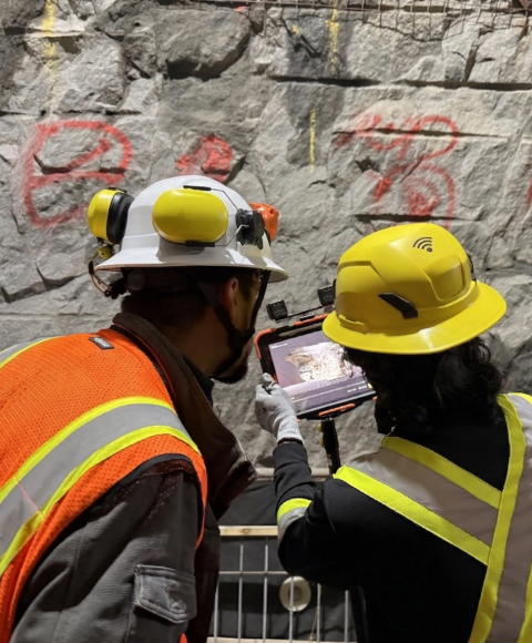
Captures geological and geotechnical data on iPad, or imports scans from your existing hardware.At the face, offline, between rounds.
Data captured in Lithos flows directly to Strata Grounded platform, where teams can review conditions, generate reports, and align on decisions.

See how GroundedAI connects daily underground observations to tunnelling decisions

© 2026 GroundedAI. All rights reserved.
Vancouver, BC · EN


