
Field observations captured with Lithos flow directly into Strata, where teams can map conditions, review data, and align around decisions.
ithos ensures every field observation enters the Grounded Platform structured, contextualized, and ready to act on
Field observations captured with Lithos flow directly into Strata, where teams can map conditions, review data, and align around decisions.


Align captured observations with location and design context. Anchor scans to chainage grids and baseline tunnel plans.


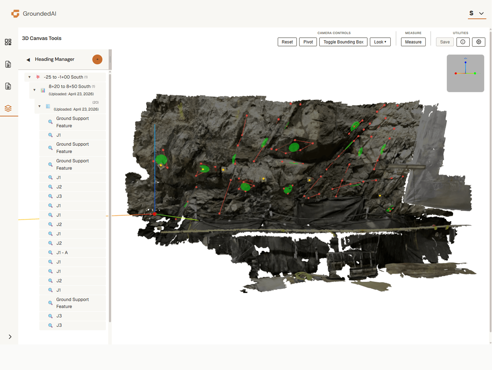
Visualize underground conditions directly within the platform. Structural tags, lithology, and rock mass data mapped in 3D.


Give engineers and managers a clear view of what is happening underground. Same data, same context, same decisions.


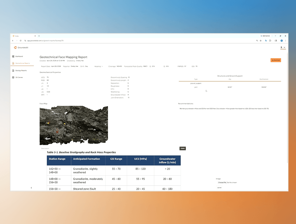
Generate audit-ready reports that capture observations and decisions. Auto-structured round reports with face images and annotation tables.


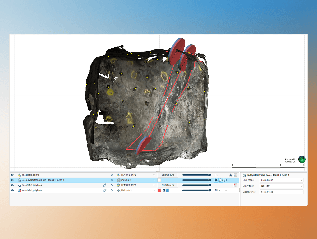
Export structured data into modelling tools such as Leapfrog, Deswik, and CAD. Clean data, open formats.

Engineers review captured scans, annotations, and observations directly in the platform.
This shared view allows teams to align quickly around what is actually happening underground.

Every observation displayed with full spatial context. Engineers see exactly what the field team captured, tied to chainage, georeferenced, and ready for classification.

Strata supports critical operational decisions with structured field data. Every decision backed by captured observations.
Confirm support compliance against design. Georeferenced records per cycle, validated before the next advance.
Review rock mass conditions with full spatial context. Q, RMR, and GSI classifications tied to 3D data.
Defensible DSC documentation. Timestamped, georeferenced, audit-locked chain of custody for every flagged event.
Strata generates structured reports and exports that can be used across engineering teams and modelling software.


Captured Scans


Mapped Observations


Structured Reports


Modelling Software

Auto-generated structured reports include face images, annotation tables, classification summaries, and comparison data. Export to Leapfrog, Deswik, and CAD formats.

Auto-generated structured reports include face images, annotation tables, classification summaries, and comparison data. Export to Leapfrog, Deswik, and CAD formats.
Auto-generated structured reports include face images, annotation tables, classification summaries, and comparison data. Export to Leapfrog, Deswik, and CAD formats.
Auto-generated structured reports include face images, annotation tables, classification summaries, and comparison data. Export to Leapfrog, Deswik, and CAD formats.
Lithos captures observations underground. Strata transforms those observations into structured insights used for mapping, reporting, and engineering decisions.
How ready is your workflow?
Answer 3 questions about how your team captures, manages, and uses underground data. Get an instant readiness score and integration roadmap.
Workflow Analysis
PDF DELIVERED


Map lithology, structures, and geological observations against 3D scan data and baseline plans.

Confirm excavation support, document DSC events, and align on cycle-by-cycle decisions.

Review rock mass conditions and validate support designs with full spatial context from the field.

Access structured field data for assessments, peer reviews, and stakeholder deliverables.

Structured field data for independent assessments, client reports, and audit-ready documentation.
Geologists can capture lithology, structures, and observations directly within the 3D scan. Captured observations are structured and immediately available for engineering review.


“We're able to identify potential hazards and make data-driven decisions that improve safety and efficiency on site”

“We're able to identify potential hazards and make data-driven decisions that improve safety and efficiency on site”
“We're able to identify potential hazards and make data-driven decisions that improve safety and efficiency on site”
“We're able to identify potential hazards and make data-driven decisions that improve safety and efficiency on site”
"If the site team hits a problem area, they can send me a scan. I can tell them whether I need to come look in person, or whether they're good to proceed."
“In our daily meetings it’s been awesome to be able to throw the scan that we took the night before up on the big screen and share it on Teams for people who aren’t there. We can show people exactly what we’re talking about. When we talk about either adding an extra bolt or interrogating an unexpected zone. It’s definitely better than pictures.”
“This is going to help out younger staff who haven’t done a lot of mapping before. They need guidance, but it’s hard for me to do remotely without seeing it. This platform helps a lot.”
"There is absolutely subjectivity to any mapping, and so to have some sort of concrete documentation that people can look at side-by-side and make a final determination of ground conditions is exactly what we need."

Data captured in Lithos flows directly into the Grounded platform, where teams can reviewconditions, generate reports, and align on decisions.


Field captures from Lithos sync to Strata when the iPad returns to connectivity. Strata builds a cumulative 3D record that's review-ready within hours of the face being mapped, not days or weeks.
Strata is a multi-user and multi-project web platform. Geologists, geotechs, engineers, and managers can each receive role-appropriate access. Every record states who captured it, when, and where.
Strata is used before the model. It structures the field observations that import to Leapfrog, Deswik, Rocscience or any other downstream software while keeping a record of the datasets captured. We don't model; we make sure the inputs are right.
When field observations are structured and shared, teams make confident decisions.

© 2026 GroundedAI. All rights reserved.
Vancouver, BC · EN


