
ithos ensures every field observation enters the Grounded Platform structured, contextualized, and ready to act on
Lithos ensures every field observation enters the Grounded Platform structured, contextualized, and ready to act on.
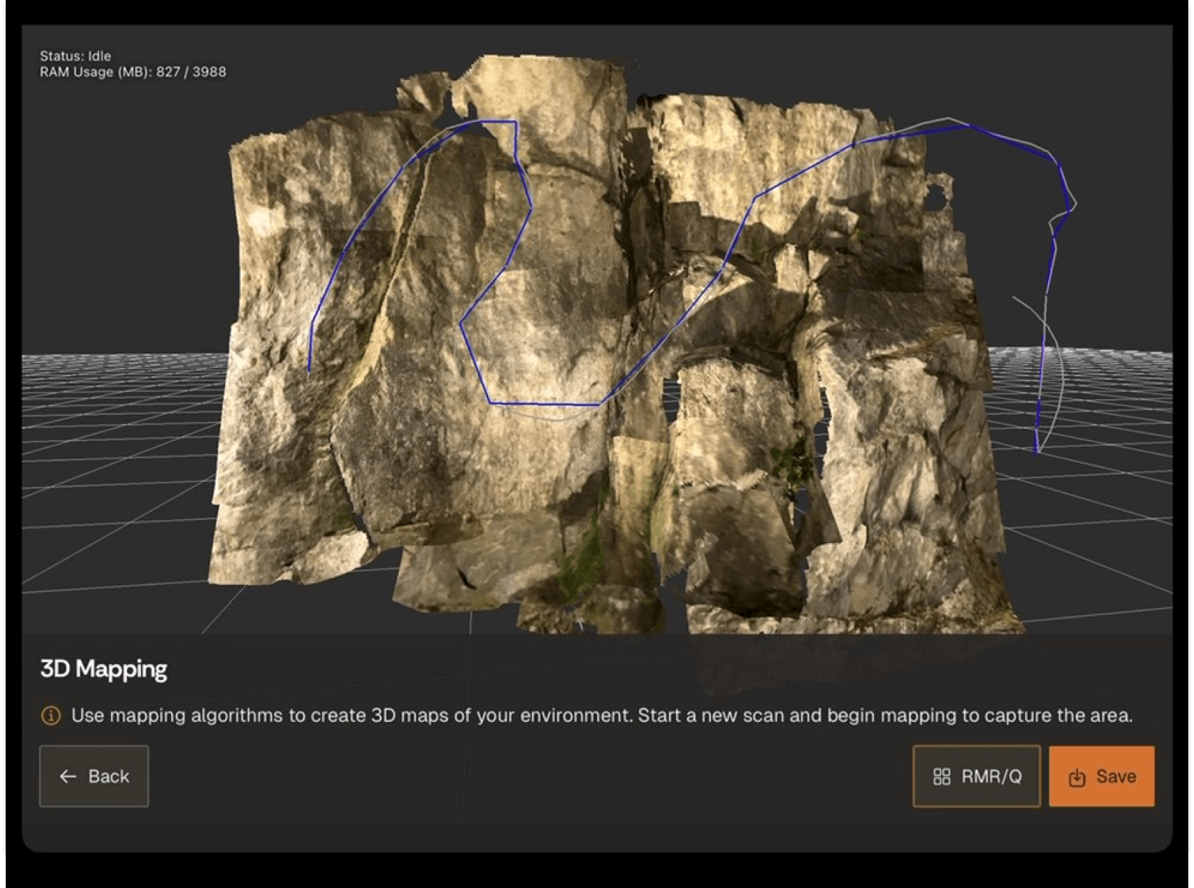
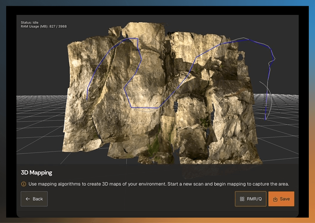
Create accurate 3D representations of underground using SLAM-based scanning. Sub-millimetre accuracy, hardware-agnostic.

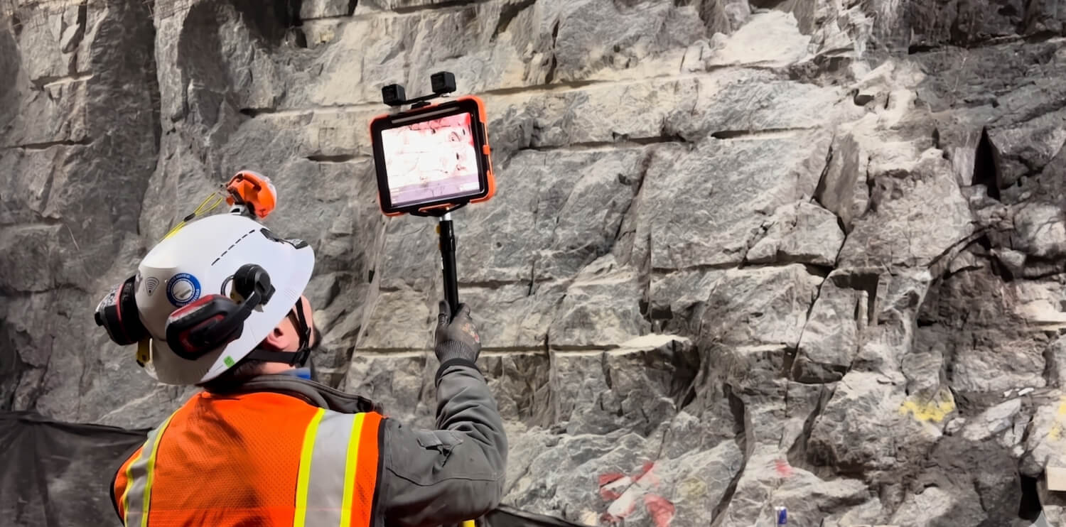
Capture high-resolution photos directly within the scan. Every image georeferenced to the point cloud automatically.

Add notes and observations directly in context. Structural tags, lithology markers, and free-text notes pinned to spatial data.

Tie observations to specific headings or chainage. Zero ambiguity about where an observation was made.

Send captured observations directly into the GroundedAI platform. Data is available on Strata before the shift engineer reaches surface.

Geologists can capture lithology, structures, and observations directly within the 3D scan. Captured observations are structured and immediately available for engineering review.
Every geological observation captured at the face enters the workflow structured, georeferenced, and decision-ready. Without any manual handoff or re-entry.

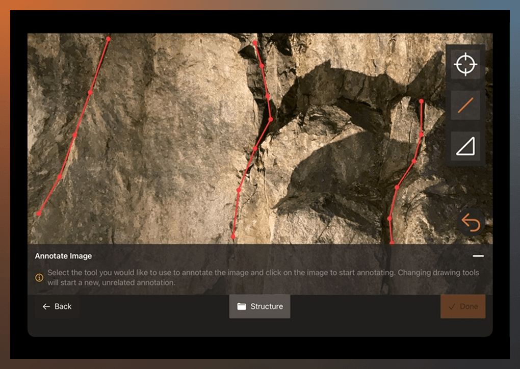
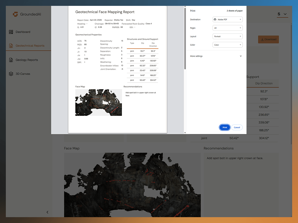
Engineers capture rock mass conditions, discontinuities, and support observations directly within the scan. Clear context for ground support and engineering decisions.

Captured observations provide the foundation for ground support decisions, compliance documentation, and engineering review.
Lithos captures data fully offline and allows engineers to capture data quickly without disrupting productive work.
Offline
Scan Accuracy
Points per Scan
Manual Re-entry
Data captured in Lithos flows directly into Strata Grounded platform, where teams can review conditions, generate reports, and align on decisions.


Structured 3D scans, photos, and annotations captured underground and connected to the decisions that follow.


Strata transforms captured field data into shared views, visualizations, and audit-ready outputs that engineers and managers can trust.


Generate reports that capture observations and enable decisions.


Export structured data into modelling tools such as Leapfrog, Deswik, and CAD. Clean data, open formats.


How ready is your workflow?
Answer 3 questions about how your team captures, manages, and uses underground data. Get an instant readiness score and integration roadmap.
Workflow Analysis
PDF DELIVERED
Data captured in Lithos flows directly into the Grounded platform, where teams can review conditions, generate reports, and align on decisions.

Capture lithology, structures, and geological observations at the face. Structured data for geological models and reports.

Record conditions shift-by-shift. Incoming crews see exactly what was captured, flagged, and handed over.

Document rock mass conditions, discontinuities, and support observations. Clear context for ground support decisions.

Access structured field data for assessments, peer reviews, and stakeholder deliverables without manual re-entry.
Geologists can capture lithology, structures, and observations directly within the 3D scan. Captured observations are structured and immediately available for engineering review.


“We're able to identify potential hazards and make data-driven decisions that improve safety and efficiency on site”

“We're able to identify potential hazards and make data-driven decisions that improve safety and efficiency on site”
“We're able to identify potential hazards and make data-driven decisions that improve safety and efficiency on site”
“We're able to identify potential hazards and make data-driven decisions that improve safety and efficiency on site”
“We're able to identify potential hazards and make data-driven decisions that improve safety and efficiency on site”
"It will replace 80, 90% of our hurdles. We are doing the pen-and-paper method with photos, driving to site, going back to the site office, then spending four to six hours just to do the bits and bobs of mapping. With this workflow, we can do more."
"We were very pleased to be able to get around the conveyor near the crown. This approach is much superior to having a scanner at a fixed point lower down, where you don't have the ability to collect data around shadow zones."
"There is absolutely subjectivity to any mapping, and so to have some sort of concrete documentation that people can look at side-by-side and make a final determination of ground conditions is exactly what we need."
“We're able to identify potential hazards and make data-driven decisions that improve safety and efficiency on site.”
"It will replace 80, 90% of our hurdles. We are doing the pen-and-paper method with photos, driving to site, going back to the site office, then spending four to six hours just to do the bits and bobs of mapping. With this workflow, we can do more."
"We were very pleased to be able to get around the conveyor near the crown. This approach is much superior to having a scanner at a fixed point lower down, where you don't have the ability to collect data around shadow zones."
"There is absolutely subjectivity to any mapping, and so to have some sort of concrete documentation that people can look at side-by-side and make a final determination of ground conditions is exactly what we need."
Data captured in Lithos flows directly into the Grounded platform, where teams can review conditions, generate reports, and align on decisions.

Yes. Lithos runs on an iPad Pro with LiDAR and supports rock mass classification input (Q-system, RMR, GSI) while underground.
Lithos captures 3D scans with 5–10mm accuracy using the iPad's LiDAR sensor.
Yes. All scanning, annotation, and classification happens locally on the iPad. Data syncs to the Strata web platform once the iPad returns to a Wi-Fi connection.
Lithos runs on an iPad Pro with LiDAR, or if your site already has a LiDAR solution you can import scans from your existing hardware.
If your team captures geological data today, we can help you turn it into clarity tomorrow.

© 2026 GroundedAI. All rights reserved.
Vancouver, BC · EN


