

Your geologists and engineers do excellent technical work in the field. The problem is everything that happens between their observations and a deliverable your client can trust.

Site mapped. Conditions assessed. Data captured by your field team across multiple active projects.


Every project has its own spreadsheet, its own folder structure, its own way of getting data from field to office. Quality depends on the individual, not the system.

Reports get assembled from scattered sources. Data gets reformatted to meet client standards. Senior staff spend time checking work instead of doing it.


New site, new client, new reporting template. Your team rebuilds the data workflow from scratch each time, and institutional knowledge walks out the door when people rotate.
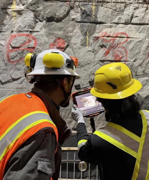
Geologists capture excellent data underground. Getting it into a structured, client-ready format takes days of manual processing that adds cost and introduces errors.
Senior engineers review deliverables at the end, catching formatting issues, missing data, and inconsistencies that should have been prevented by the workflow, not found in review.

Standardize how your field teams capture geotechnical data across sites, across clients. Consistent inputs mean consistent deliverables, regardless of who's on site.

Give every geologist the same capture framework for discontinuities, joint sets, and structural data. Build a geological record that meets client standards from the moment it's captured.

When field conditions diverge from project assumptions, document it with structured data not narratives written weeks later. Protect your client and your firm.
Consistent deliverable quality regardless of who's assigned to site.
Field-to-report turnaround measured in hours, not days.
QA built into the capture process, not bolted on at the end.
Workflow Analysis
PDF DELIVERED


"We had twelve active tunnel projects last year, each with its own way of getting geological datafrom field to report. The best geologist in the firm shouldn't be the only one who produces reliabledeliverables."

"We had twelve active tunnel projects last year, each with its own way of getting geological datafrom field to report. The best geologist in the firm shouldn't be the only one who produces reliabledeliverables."
"We had twelve active tunnel projects last year, each with its own way of getting geological datafrom field to report. The best geologist in the firm shouldn't be the only one who produces reliabledeliverables."
"We had twelve active tunnel projects last year, each with its own way of getting geological datafrom field to report. The best geologist in the firm shouldn't be the only one who produces reliabledeliverables."
"If the site team hits a problem area, they can send me a scan. I can tell them whether I need to come look in person, or whether If the site.... good to proceed."
“This is going to help out younger staff who haven’t done a lot of mapping before. They need guidance, but it’s hard for me to do remotely without seeing it. This platform helps a lot.”
"It will replace 80 or 90% of our hurdles. We are doing the pen-and-paper method with photos, driving to site, going back to the site office, then spending four to six hours just to do the bits and bobs of mapping. With this workflow, we can do more."
"In rehab work, it can be used to identify locations of interest, leaks or spalls, anything we want to come back to when we're in a tunnel and trying to map deficiencies. It would be perfect for our upcoming project."

Data captured in Lithos flows directly into the Grounded platform, where teams can review conditions, generate reports, and align on decisions.

See how GroundedAI gives consulting teams consistent capture and reporting across every underground project.

© 2026 GroundedAI. All rights reserved.
Vancouver, BC · EN


